We parked at Stiffkey adjacent to the North Norfolk Coastal Path, the walk started following the coastal path
We had quite a long walk along the path with tremendous views across the inlets and salt marshes towards the sea, for quite a while we thought we had gone wrong but eventually realised we were right.
It became increasingly obvious that we had done the walk before, and we are sure we were with Kira and Steven and did an Easter Egg Hunt on Cockthorpe Common, i have tried unsuccessfully to find the pictures.
We passed Stiffkey Fen, we eventually turned off the Norfolk Coastal Path
Well on this walk i finally got beat by the Stiles, i struggled getting up and down.
Then we saw cows in the distance and Bob said they sound like sheep, gullible me agreed, until he said There are sheep in the next field, of course, i couldn't see them over the hedge.
Bob said look at all those dead caterpillars so i looked again gullible me, i think they were catkins.
Then we crossed a bridge and entered Cockthorpe Common and went through a field with Sheep and Lambs, it was beautiful but scary!!
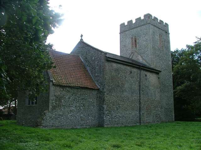
Then we continued into Cockthorpe, we passed All Saints Church, Cockthorpe, which was unused, the gardens were kept in trim by sheep, how sensible.
We then continued down into Stiffkey crossing the River StiffkeyAll Saints, Cockthorpe
All Saints, CockthorpeCockthorpe has a tiny church on the lonely outskirts of Stiffkey, so it is not surprising that it has been declared redundant. Cordoned off within the perimeter fence of a WWII aerodrome, derelict for decades, it was finally thought worth saving, and is now in the loving care of the Norfolk Churches Trust. The pretty little graveyard is overgrown and tree-surrounded, and in an intensely rural setting, among fields, copses and small farms.
All Saints underwent a comprehensive rebuilding in the late 15th century; only the chancel, virtually a lean-to shed, survives from an earlier era, but it has been seriously battered over the centuries since. From the south, the smallness of the church is jewel-like, almost perfect, with a tiny aisle and clerestory beneath the earlier tower rising above. This aisle has been dated as early 14th century, on account of the tracery in the window, but I think this window has been reset here later from elsewhere. Whatever, it is lovely.
On the north side, however, there is no aisle, no clerestory, not even any windows; just a sheer blank wall, as if you had stepped behind a stage set. The lower wall is the original wall, the upper part a 15th century extension. Perhaps it was done temporarily, and an aisle was planned, to be followed by a clerestory. But none of it ever happened.
We stopped at Stiffkey coffee shop for well earned rest
We then continued back to the car. On the way home we stopped into Wells for ice cream and toilets and spotted this.......
 |
| Bored Husbands |
Stiffkey
Stiffkey
Stiffkey Salt Marsh
Stiffkey shown within Norfolk
Area 14.55 km2 (5.62 sq mi) Population 223 - Density 15 /km2 (39 /sq mi) OS grid reference TF 971 430 Parish Stiffkey District North Norfolk Shire county Norfolk Region East Country England Sovereign state United Kingdom Post town WELLS-NEXT-THE-SEA Postcode district NR23 Police Norfolk Fire Norfolk Ambulance East of England EU Parliament East of England UK Parliament North Norfolk List of places: UK • England • Norfolk
Stiffkey (often pronounced Stewkey) is a village and civil parish on the north coast of the English county of Norfolk. It is situated on the A149 coast road, some 6 km (3.7 mi) east of Wells-next-the-Sea, 6 km (3.7 mi) west of Blakeney, and 40 km (25 mi) north-west of the city of Norwich.[1]
The civil parish has an area of 14.55 km2 (5.62 sq mi) and in the 2001 census had a population of 223 in 105 households. For the purposes of local government, the parish falls within the district of North Norfolk.[2]
The place-name 'Stiffkey' is first evidenced in the Domesday Book of 1086, and means 'stump island, island with stumps of trees'.
The village is remembered as the parish whose rector, Harold Davidson, fought one of the last morality trials of the Church, under the ancient morality laws of the Church, in 1932. The laws were repealed in the wake of it. He was an extremely popular priest in the area and the villagers asked his family to allow him to be buried in Stiffkey when he died, rather than in the family tomb in Scholing, where he was born. (He was killed, rather improbably, by a lion). They have cared for his grave for many years.
The author Henry Williamson bought a farm in Stiffkey. The Story of a Norfolk Farm (1941) is his account of his first years of farming here.
On 11 May 1978, the author, soldier and politician Aubrey Buxton was created a life peer as Baron Buxton of Alsa, of Stiffkey in the County of Norfolk. He died there in 2009.
Stiffkey is also famous for cockles Cerastoderma edule which still retain the old name of "Stiffkey blues". These are stained blue by the mud in which they live.
The River Stiffkey runs through the village, from which it takes its name, and used to power the Stiffkey watermill which was built before 1579. It was a small mill, running two pairs of stones, and it operated until 1881 when it was put up for auction as a warehouse. Little now remains of the mill: just a few low ruined walls showing the position of the building.[3]
The Norfolk Coastal Path runs between the village and the sea.


No comments:
Post a Comment